| Map to Camp Grimes |
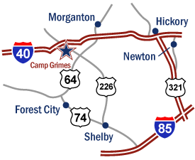 |
FROM CHARLOTTE:
I-85 through Gastonia to US 74 West exit, just past Gastonia.
Follow 18 miles - past Shelby.
Turn right on US 226, follow 31.1 miles to Vein Mountain Road.
Turn left, go 3 miles to camp entrance on left.
Time: about 1 hour, 45 minutes from downtown Charlotte.
Alternate Route:
I-77 North to I-40 to Statesville.
I-40 to 226 South at Marion, 226.
Approximately 10 miles to Vein Mountain Road. |
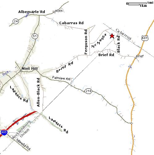
| Map to Belk Scout Camp (formerly known as Clear Creek) |
|
FROM HUNTERSVILLE:
Take Hwy 115 to W. T Harris Blvd. Turn left at the light and go till you get to Albemarle Rd. Turn left at the light until you reach Cabarrus Rd (across from Clear Creek Elementary). Turn right onto Cabarrus Rd, then turn right onto Ferguson Rd. Turn left on McManus Rd, then turn right onto Blac Rd. The main entrance is on the left at the bottom of the hill.
FROM CONCORD/KANNAPOLIS:
Take Hwy 29 to Hwy 601. Bear left onto Hwy 601 at Fire Station #3 and the old Fairgrounds. Take Hwy 601 until you get to Brief Rd. Turn right onto Brief Rd, then turn right onto Black Rd. The amin entrance will be on your right at the bottom of the hill.
|
|
This page is maintained by Rick Cardenas, ASM & IT
Director of Troop 19
Send comments to webmaster@bsa19.org
Mecklenburg County Council, Boy Scouts of America.
Charlotte, North Carolina
No content may be reproduced for non-Scouting
purposes.
© Copyright Troop 19, 1998 -
2011
Last Updated: September 5, 2011
|
|